Les travaux paysager du domaine de Meudon ont été réalisés, pour les plus importants, entre 1654 et 1695.
Une première période de travaux a eu lieu entre 1654 et 1679 lorsqu’Abel Servien, surintendant des finances, devient propriétaire du domaine. Une seconde se poursuit entre 1679 et 1695 lorsque François Michel Le Tellier, marquis de Louvois et ministre de Louis XIV, lui succède.
On reconnaît la paternité du dessin de l’axe, des jardins et des bassins du château de Meudon à Louis Le Vau et André Le Nôtre. Ces deux architectes-paysagistes avaient déjà collaboré sur le château de Vault-Le-Vicomte.
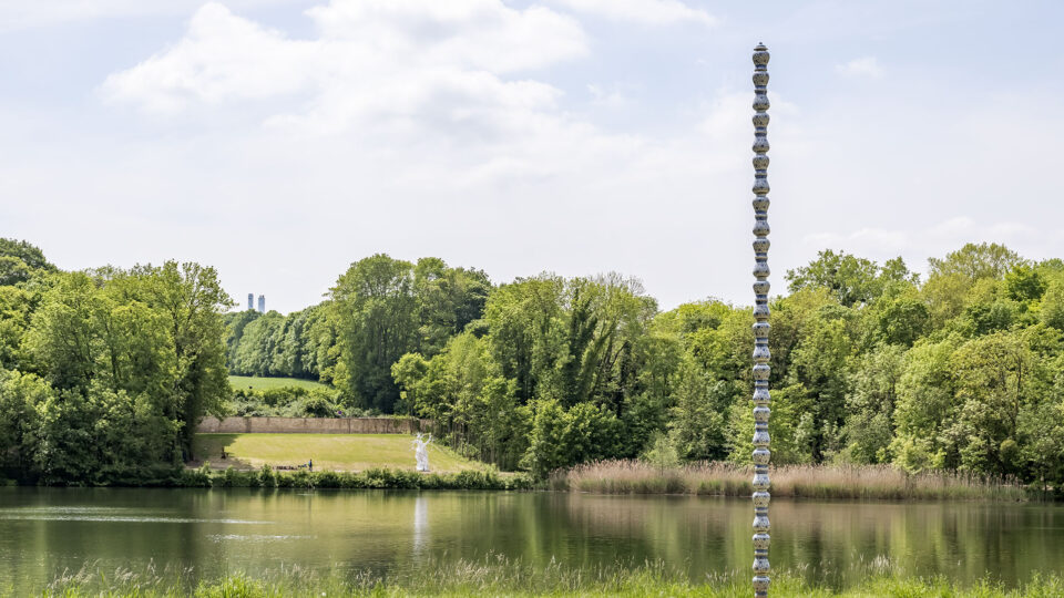
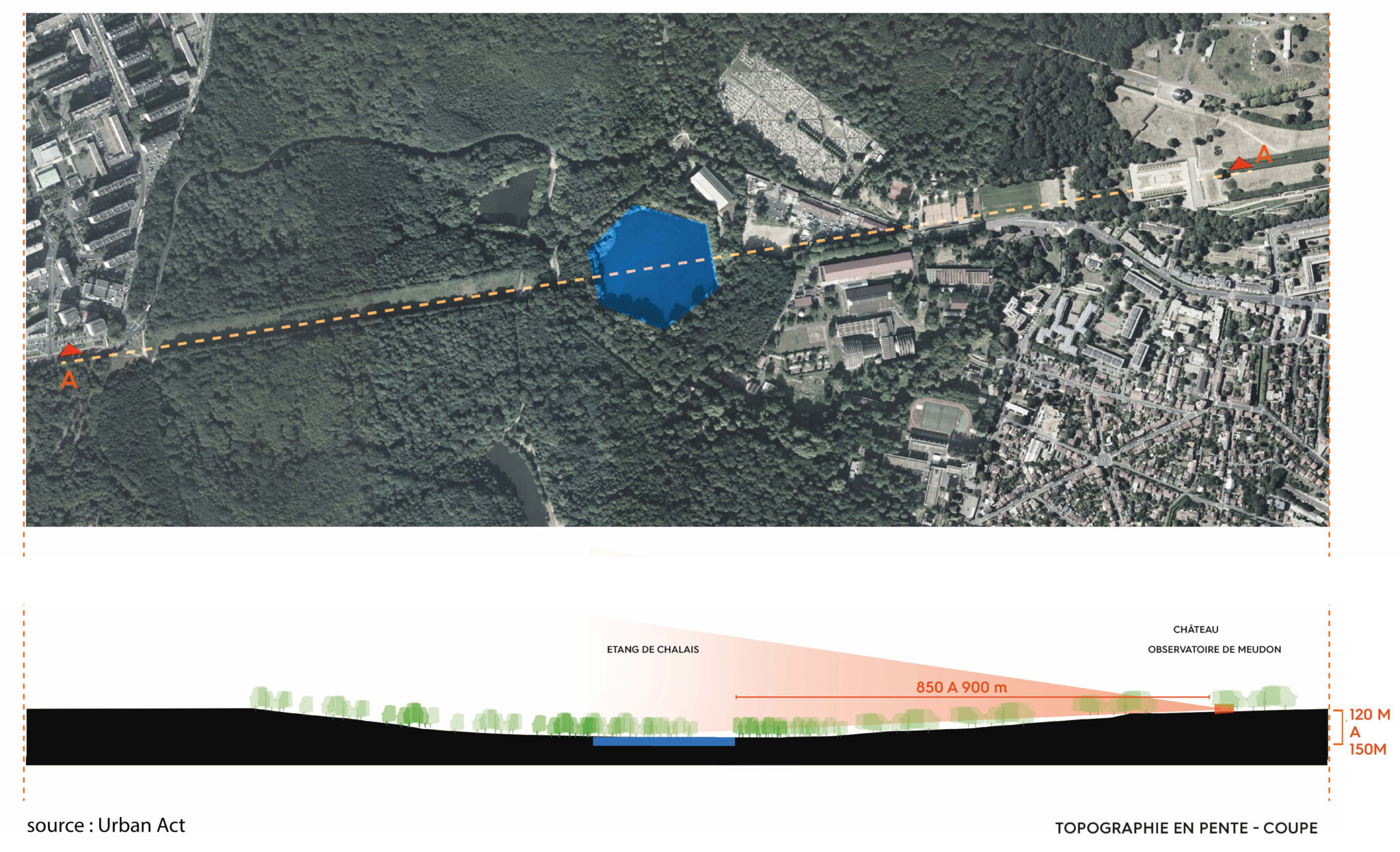
Lorsque Le Nôtre intervient sur le projet vers 1680, l’axe projeté depuis l’observatoire se dessine comme un lien évident entre ville et forêt. Cette perspective grandiose s’inscrit et met en valeur la géographie singulière du site, au creux de laquelle elle positionne le bassin hexagonal comme un miroir dans lequel le château peut se refléter.
EPISODE 2 : Le sous-bois
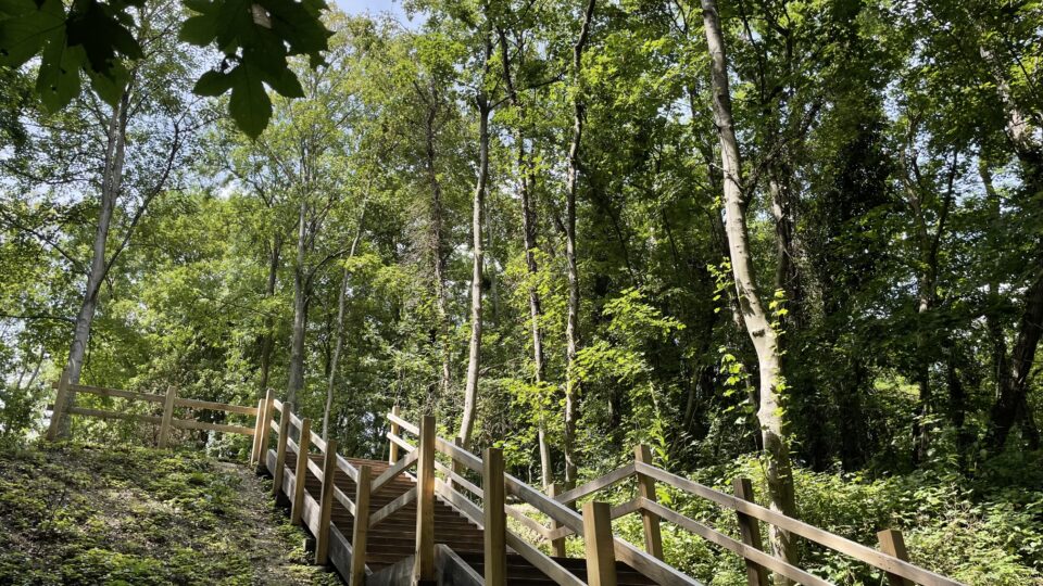
Pourquoi cet escalier ? Pour franchir ce talus. Mais d’où vient ce talus ?
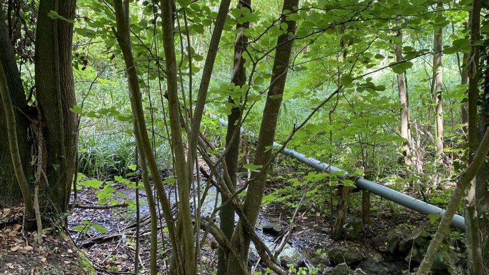
De la prairie ouverte au jeune boisement : une nouvelle promenade dans le creux du revers
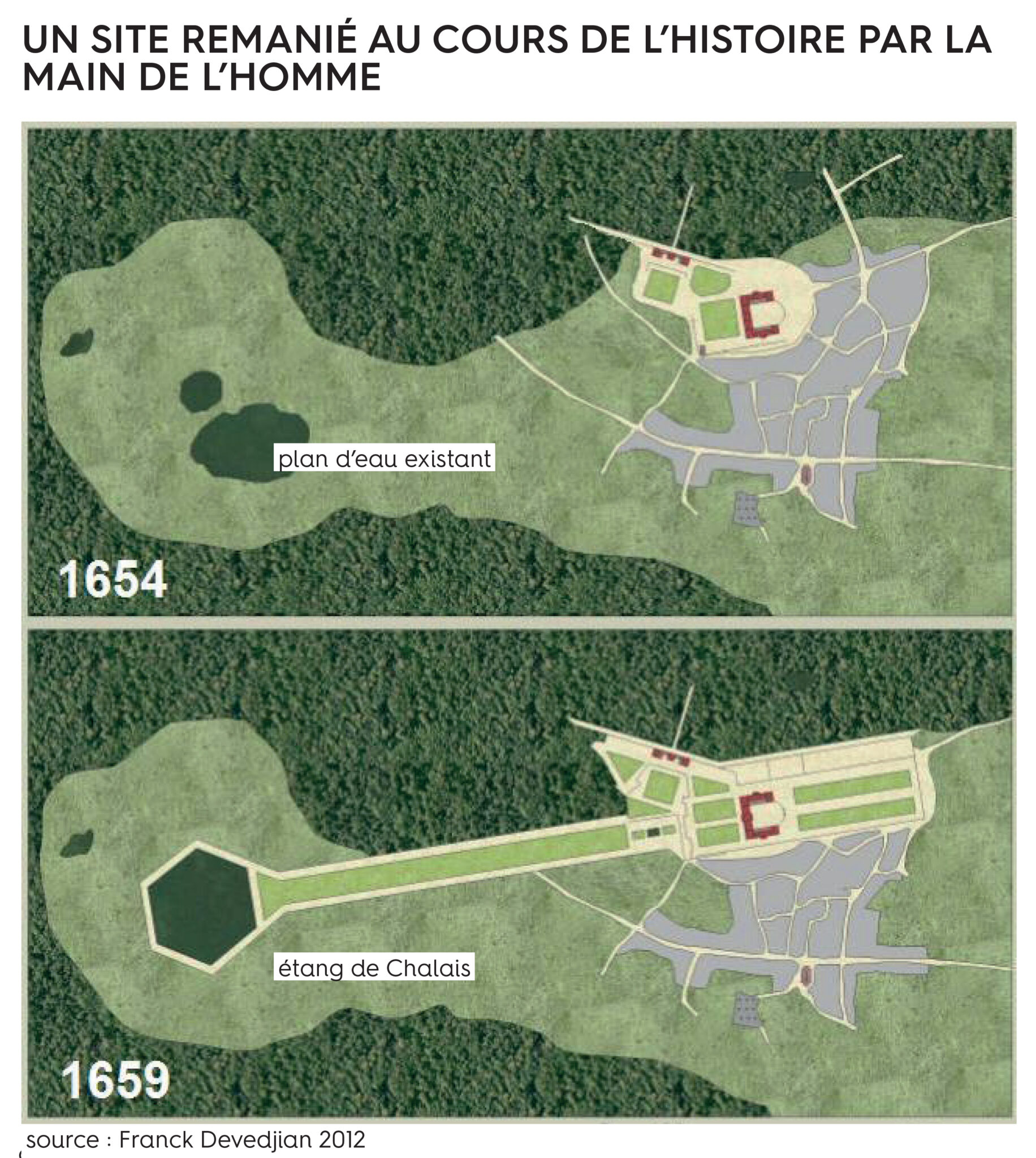
Pour créer le bassin de Chalais, Le Nôtre a dû mettre le sol de la prairie préexistante à l’horizontale. Le talus vient des terres ajoutées pour niveler le sol. La prairie était au niveau où se situe maintenant cette balade qui glisse entre les arbres.
De ce vaste terrassement résulte le bassin, superbe miroir horizontal qui capte le ciel et les nuages en même temps qu’il reflète la lumière. Si vous venez tôt le matin par un journée ensoleillée, vous serez étonné par le déploiement de cette lumière qui traverse les arbres et donne au lieu une part de mystère.
Pensé pour être imperceptible à l’œil depuis l’axe monumental, ce talus positionne le bassin en surplomb de la prairie historique, dont le niveau du sol historique devient de fait plus difficilement accessible. Et alors qu’il constituait une trace de l’origine du site, marquant la lisère entre champs et prairie, il a été peu à peu délaissé.
Ainsi, depuis une cinquantaine d’années, un boisement s’y développe. Les arbres situés là sont plus jeunes (robiniers, charmes, hêtres…).
Recréer une promenade là, entre les arbres nouveaux et à l’ombre du revers, permet d’offrir un endroit frais, propice à la déambulation. Au plus proche de la terre, à un mètre de profondeur, c’est 13°C d’assuré toute l’année, été comme hivers.
EPISODE 3 : Les milieux naturels
Un patrimoine tout à la fois écologique, historique et culturel
Crédit : ADAGP, Paris, 2030 / Luc Boegly
Bien que situé à la limite de la zone naturelle de la forêt de Meudon, le parc en est complètement déconnecté par son mur d’enceinte.
Un diagnostic patrimonial historique a permis de constater qu’il n’y avait pas d’arbres sur le site au moment où l’axe a été créé. En lieu et place des boisements actuels, une grande prairie en pente douce mettait la forêt à distance de la ville. On retrouve des traces de cette prairie jusqu’en 1930 avant que le site ne s’enfriche peu à peu. Aujourd’hui devenu un boisement pionnier, cet enfrichement rend difficile la lecture de l’axe historique.
Un diagnostic paysager et écologique a mis en évidement un effondrement de la biodiversité, causé par l’enclavement et l’abandon du site depuis plus de 50 ans.
En ce sens, un plan de valorisation du patrimoine écologique a été mis en œuvre pour reconnecter, faire respirer et ouvrir les milieux existants. Il s’est basé notamment sur la conservation des boisements anciens et matures et des arbres à cavités, qui sont les plus propices à l’accueil d’une faune diversifiée.
La qualité des boisements étant très inégale sur le site (essences, âges, ports, alignements, densités, états phytosanitaires…), le projet paysager s’est attaché à renforcer les différents milieux et la qualité biologique des espaces arborés par une gestion « brin par brin ». Ainsi, un principe de sélection fin a été mis en place pour jauger puis conserver en priorité les arbres selon leurs qualités structurelles, écologiques et historiques.
Des coupes d’éclaircies des boisements ont été effectuées en privilégiant le développement des essences les plus nobles : les frênes, les charmes et les érables champêtres. Les arbres qui s’étaient développés le long des berges, ayant pris racine sur un sol fragile, ont dû être abattus. Pour tous les espaces arborés, les espèces exotiques envahissantes qui ont pris possession du site à certains endroits, comme les ailantes ont été systématiquement supprimées.
EPISODE 4 : Les eaux
Un paysage hydraulique au cœur de la forêt : des sources, des ruisseaux, des étangs et des bassins
Crédit : URBAN ACT
Crédit : URBAN ACT
Crédit : URBAN ACT
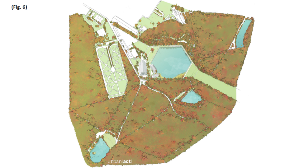
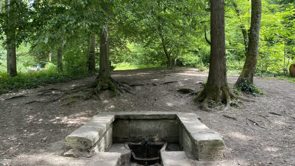
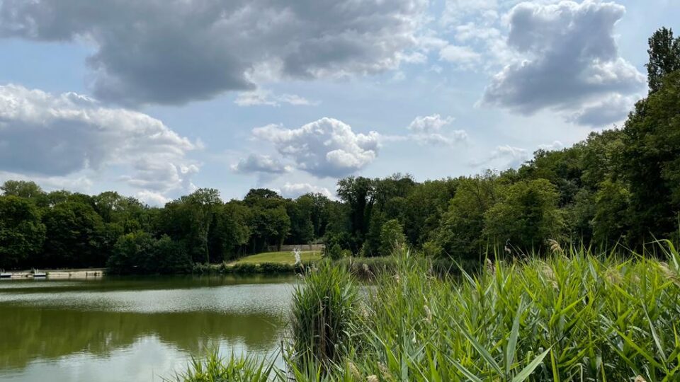
Par sa géographie marquée, la forêt de Meudon draine un bassin versant important. L’eau est partout dans la forêt : plusieurs étangs, à géométries plus ou moins rationnelles, viennent ponctuer les déambulations des promeneurs (Fig.6). Des sources souterraines alimentent en continu des fontaines comme celle de Sainte-Marie (Fig. 7), à l’est du bassin de Chalais.
La réalisation d’un réseau hydraulique intégré dans le paysage pour alimenter les plans d’eau est un enjeu à la fois ambitieux, complexe et capital. Il s’inspire fortement des réseaux mis en place à Versailles pour alimenter les fontaines et les jets d’eau des grands jardins. Par cette ingéniosité, le patrimoine de Le Nôtre réside autant dans cette gestion des eaux que dans le dessin du paysage.
Les nappes souterraines sont parfois affleurantes et alimentent les étangs en même temps que de petits ruisseaux les connectent les uns aux autres, à l’instar de celui qui relie l’étang de Chalais (Fig. 8). Le lit de ce petit ruisseau a été réparé et un petit pont créé pour pouvoir faire le tour du bassin.
Les deux berges situées de chaque côté du ruisseau n’ont pas été réhabilitées. Elles permettent de prendre conscience de l’impact de la végétation sur les pierres et sur ce patrimoine culturel unique construit de la main de l’Homme. En trois siècles les arbres ont pris racine dans les pierres et ils les ont pratiquement entièrement détruites.
EPISODE 5 : Le bassin de Chalais
Une géométrie sans limite entre architecture et paysage ?
Crédit : URBAN ACT
Crédit : URBAN ACT
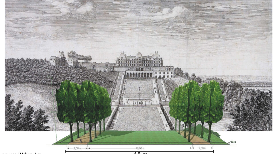
L’axe historique, large de 68 mètres, est composé par une pelouse de 48 mètres de large, longée par deux allées de 9,5 mètres, elles-mêmes bordées de chaque côté par des alignements de tilleuls (Fig.4)
Dans le dessin de Le Nôtre, l’architecture et le paysage ne font plus qu’un lorsqu’à l’endroit où l’axe rencontre le bassin, l’un des côtés de l’alignements de tilleuls s’interrompt pour laisser place à la pierre et ainsi dessiner et souligner le bassin en positionnement le tapis vert tout autour du bassin et le boisement en retrait.
Le bassin est un hexagone régulier de 110 mètres de côté : une géométrie si parfaite, si justement positionnée et alignée dans l’axe, qu’elle en deviendrait presque sacrée.
Le Nôtre conçoit l’hexagone en deux temps :
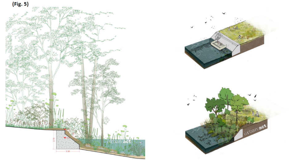
- Il vient d’abord le délimiter par un perré, souligné par un alignement de pierres épaisses positionné à 1 mètre au-dessus du niveau de l’eau. Comme explicité par ces schémas, la géométrie de ce perré encadre et limite le miroir d’eau (Fig.5) , lui conférant sa forme et son épaisseur si particulière.
- Dans un second temps, l’hexagone du bassin est couronné par un alignement d’arbres disposé à 9,5 mètres en retrait du perré, à l’arrière de la pelouse (tapis vert) situé au centre de l’axe historique.
EPISODE 6 : Patrimoine culturel, patrimoine écologique
Crédit : URBAN ACT
Les roselières et le bassin
Avec le temps, le bassin s’est chargé de sable et de sédiments charriés par les eaux de ruissellement. Tant et si bien qu’à un endroit du bassin, l’affleurement de cet amas donnerait presque le sentiment de pouvoir marcher dessus.
Des roselières se sont développées et tiennent une place importante sur l’eau. Ici, peut-être plus qu’ailleurs, un dilemme cornélien s’impose : comment choisir entre patrimoine culturel et patrimoine écologique ? Si ces roselières portent atteinte au tracé hexagonal pensé par Le Nôtre, elles représentent un milieu intéressant pour l’avifaune et l’entomofaune.
Il a finalement été décidé de conserver ces roselières car, face à la géométrie de Le Nôtre, elles définissent un autre paysage indispensable pour les années à venir. Elles sont la preuve que la végétation, le sol, peuvent en quelques dizaines d’années faire complétement disparaitre les œuvres construites. Ces roselières sont le signe d’un paysage en mouvement, d’une végétation qui altère et remplace, en quelques années, notre patrimoine culturel. Nous voulions mettre en avant cette ambiance d’un paysage singulier, mais aussi cette reconquête en cours du végétal sur le construit.
Un patrimoine en péril
Cette reconquête du végétal s’est aussi faite par les arbres qui ont colonisé les berges, au point que certains ont poussé sur l’hexagone, à même les pierres du perré.
Au début de sa croissance, un jeune arbre ne constitue pas un danger. En revanche, lorsqu’il atteint plus de 15 mètres de hauteur et qu’il grossit en conséquence, la berge n’a plus la capacité de résister. Il suffirait alors d’un vent plus fort que d’habitude pour que l’arbre finisse par tomber, arrachant une partie de la berge historique qui, dès lors, s’effondrerait dans le bassin (Fig.9).
EPISODE 7 : Les arbres remarquables
Entre conservation et renforcement du patrimoine arboré
Crédit : URBAN ACT
Chaque arbre possède une silhouette singulière, donnée par le diamètre de son tronc, sa hauteur et l’épaisseur de son houppier. Selon la qualité de leurs silhouettes, leurs caractéristiques, ainsi que leurs qualités physiques et structurelles, les arbres les plus remarquables ont été conservés et valorisés.
Malgré le fait qu’il soit situé dans l’axe historique, l’allure unique du platane, son tronc très haut et élancé, son houppier très fourni, sa prestance et sa robustesse ont permis d’en faire un élément ponctuant le paysage et la promenade.
Un peu plus loin en direction de l’étang, sur la berge située à gauche du platane, un très haut marronnier a poussé en cépée, avec trois troncs qui partent de la même souche.
Au total 40 arbres ont dû être coupés en raison de leur mauvais état, de maladies ou de problèmes de stabilité.
En retour, nous avons plantés plus de 1300 arbres sur le site :
- 176 arbres de 25 cm de diamètre et 4 mètres de hauteur minimum.
- 187 arbustes de 6 à 8 cm de diamètre et 50 cm à 1,5m de hauteur.
- 978 arbustes de 40 à 50 cm de hauteur.
C’est parce que nous nous sommes engagés à réhabiliter un patrimoine à la fois historique, écologique et culturel que la valorisation du site est exceptionnelle. Elle vient réparer les traces du passé en même temps que prendre un engagement fort dans la construction de l’avenir, et positionner l’architecture en solidarité avec le paysage et non pas à côté ! (Fig.10)
Textes : URBAN ACT